Inter-Intelligence Communications
http://inter-intelligence-communications.com/?tag=pleiadean
Exploring Inter-Intelligence Communications and Consciousness Expansion
Posts Tagged ‘Pleiadean’
Flat-Map Alignments: Bridging the Crop Circle Gap
Monday, December 16th, 2013
The following flat-map alignments communicate a connection between US and UK crop circles via the Pleiades, the Bermuda Triangle, and the St Michael ley which runs through crop circle country in southern England:
Explore an interactive version of this map - which stems directly from the original Triangle Alignments and associated maps linking Pleiades with the TIP line via the Wilbur 2012 circle and with the Hopewell Mounds 2012circle via Bear Butte.
Please remember that these maps are in no way intended to reflect the spherical nature of Earth. The flat map is simply the surface on which messages from the Other Intelligence can be written, using a language comprised of symbols and ideas that are anchored on the planet and graphically depicted through geometry.
The TIP line that started all of this back on 16 June 1995 was relatively short, which when depicted on a  spherical map is a nearly identical line. For the three points in that first contact (Topeka, Inman, Plevna) to fall with almost mathematical precision on one line was, to me, no accident. Millions and millions of square miles, as seen on this map, make even flat maps less user-friendly - which is why there is no “exactness” to this map. The angles change subtly and sometimes not so subtly as you zoom in closer or zoom out. Like crop circle synchronicities, these flat-map alignments are a way for the Other Intelligence to tap on our shoulders and say “take notice here.“ I find the resonance between the size, shape, and position of the original triangle alignments map and the Bermuda triangle noteworthy in this regard.
 spherical map is a nearly identical line. For the three points in that first contact (Topeka, Inman, Plevna) to fall with almost mathematical precision on one line was, to me, no accident. Millions and millions of square miles, as seen on this map, make even flat maps less user-friendly - which is why there is no “exactness” to this map. The angles change subtly and sometimes not so subtly as you zoom in closer or zoom out. Like crop circle synchronicities, these flat-map alignments are a way for the Other Intelligence to tap on our shoulders and say “take notice here.“ I find the resonance between the size, shape, and position of the original triangle alignments map and the Bermuda triangle noteworthy in this regard.
My father’s first cousin Bobby disappeared in the Bermuda Triangle in 1954, so I have a personal connection to that mysterious place. Despite the smear campaign against it, as with crop circles, the Triangle really is a mystery. Could it be a portal between dimensions or worlds - and could the Other Intelligence associated with the crop circles therefore be sending a message with this map that they are associated with the Pleiades and that they utilise the Bermuda Triangle as a portal to visit Earth?
IMPORTANT NOTE: If you are new to Flat-Map Alignments, please see FMAs: FAQs.
STACE TUSSEL COLLIGAN
Pleiades Link to Hopewell Mounds Crop Circle
Tuesday, October 30th, 2012Research with a geomantic bent reveals a combined Native American and Pleiadean theme running through various US crop circles, including the most recent near Chillicothe, Ohio. The Hopewell Mounds formation links directly to Bear Butte and the Pleiades in yet another predictive alignment, making me wonder if these alignments are in fact a built-in utility by which we may elucidate communication.
In any case, over the past several months the alignments map has evolved from a basic triangle into a complex network of geometric connections between and among crop circles and Native sacred places. Bear Butte, Devils Tower, and Chaco Canyon are on the map, and each has a direct and specific link to the Pleiades star system. Additionally, the alignments map connects both of this year’s US formations to the Pleiades summit in northern Washington State, thereby circling back to the “Pleiadean Communication” that infused my first crop circle experience which, uncannily, itself occurred on a predictive alignment!
Click link to access interactive All-in-One Crop Circle Alignments Map
The crop formation at the Hopewell Mounds earthworks site has a clear Native American tie leading into the realm of prehistory. Two millennia ago, the culturally advanced Hopewellian peoples living primarily in southern Ohio dispersed under unknown circumstances, and recent research indicates that the Lakota Sioux are one of a few remaining tribes sharing DNA with the Hopewell groups in a connection which can be traced back 15,000 years to ancestors on the Asian continent.
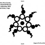
In an unambiguously symbolic alignment, the 2000 mile line extended from the Hopewell circle directly to the Pleiades summit passes within two miles of Bear Butte. The shape of the formation itself even resonates with the “seven stars” of the Pleiades by virtue of both its sevenfold geometry and a numerological interpretation of the formation’s total number of components, i.e., 36 circles and 7 rings, for a total of 43, and 4 + 3 = 7.
Onsite research led by Jeffrey Wilson of ICCRA and laboratory analysis by WC Levengood indicate that the Hopewell circle is of unknown origin. They found pronounced variability in the height at which the corn stalks bent over throughout the formation as well as extreme biological malformations in the affected corn, both of which would be difficult or impossible to duplicate with conventional circlemaking methods.
IMPORTANT NOTE: If you are new to Flat-Map Alignments, please see FMAs: FAQs.
STACE TUSSEL COLLIGANNote: Similar height anomalies and biologic evidence uniquely appear in the 2012 Hopewell and 2006 Herington, Kansas formation. Herington’s connection to the Pleiadean theme is evident by its specific location on the all-in-one alignments map and its representative shape.
Selected References: A Little History of Astro-Archaeology, by John Michell. Hopewell Ancient DNA Research. Astronomy in the Ancient Americas. Hopewell Lakota Sioux. Jeff Wilson and ICCRA. WC Levengood’s laboratory analysis reported at Earthfiles.
Look Who’s Talking in Wilbur: The Other Intelligence Chimes In on Crop Circle Alignments
Sunday, October 7th, 2012Two crop circles have appeared in the United States since my alignments map was posted in July, and each independently reveals a connection to the Other Intelligence. Both the Wilbur and Chillicothe circles, in fact, can even be read as deliberate replies to that map explication. Indeed, what other form would such a reply take?
Speculation aside about exactly how the circle came to appear in the field, consider the evidence pointing to the involvement of the Other Intelligence in Wilbur’s design and geographic placement. Through the interpretive keys of shape, synchronicity and alignment, what understanding might we derive from these new circles? Are map alignments a litmus test for communication with the Other Intelligence?
Shape and Synchronicity “Where the Lightning Strikes”
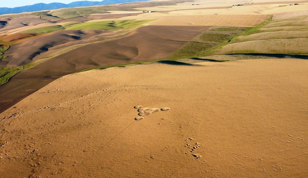
Wilbur 2012 appeared almost like a comment written in wheat a few days after I published The Sum of Its Parts: Finding Emergent Meaning in Crop Circle Maps. The diagram was immediately and intensely hypnotic; something about it drew me in completely. I found the formation’s threefold geometry graceful and balanced, echoing the triangular alignments map.
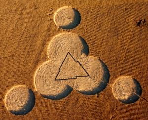 Looking past the relatively-simple outer borders of the formation we see a dynamic inner triangle in the wheat, created by the floor pattern. The triangle’s luminous zigzag border is comprised of three lightning bolts joined to form a triangle shining up from the circle’s floor. For clarity, I’ve outlined it in the photo here. What could it mean?
One book used in my research for the alignments map
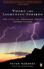 explication was Where the Lightning Strikes: The Lives of American Indian Sacred Places, by Peter Nabokov. Weeks earlier, the book had been central to a smallish synchronicity when I had first opened the it randomly to the page dedicated to Bear Butte. The zigzag feature of the Wilbur 2012 crop circle seems to be saying, “Look! Here is where the lightning strikes.”
And then there was the time lightning from a clear blue sky struck very near me in Kansas, in the utter absence of any storm - an event without mundane explanation. I associate the errant lightning with the UFO sightings and apparent ET encounters involving electricity that I was experiencing fairly frequently at the time, contact which reached a peak with the arrival of crop circles in my life in 1995.
Might electricity itself be a clue from the Other Intelligence? I just now looked online and found a brief 1985 article in The New York Times titled “Electricity May Play Role in Plant Growth.” The article reports that researchers had shown that, depending on the direction of the current, plant growth was either accelerated or stunted by the application of electricity. The premise that electricity can be applied to affect plant growth is demonstrated in my own living room, where a 4-foot tall hibiscus tree stands near the television, and the branches directly over the back of the TV set have leaves twice or three times the size of the other leaves. I wonder if the Herington, Kansas crop circle, which showed a full range of accelerated and decelerated growth while in the field, may have carried information about the potential applications of the circlemaking energy, which may be electric in nature. I haven’t yet explored possible alignment map correspondences with the Herington formation, but with this new insight in mind, another article may be in the offing.
A Path to the Pleiades Via Crop Circle Alignments
When we actively seek to interpret the messages carried by crop circles, we find that shape alone barely scratches the surface. Synchronicities help refine the unique meaning we derive from a given formation, which may in turn assist us in deciphering universal messages as well. Map placement, especially with a predictive quality, has been offered as a possible indicator of the Other Intelligence, since many of the alignments I’ve found thus far suggest an omniscient presence working behind the scenes. So naturally, the next step in deciphering Wilbur 2012 involves plugging it in to the existing alignments map.
As I anticipated, Wilbur created a new and especially pertinent alignment: The 860-mile long direct line
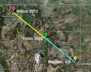 between myself and the Wilbur circle is lengthened by only two miles if we factor in a slight detour to the Teton circle.
Once this line was established, I noticed that if extended beyond Wilbur, the line continued on through the mountainous region of northern Washington. Wouldn’t it take the cake if it led directly to the Pleiades Mountain summit in the North Cascades? I was disappointed when I found the line didn’t match up, but I was compelled, nonentheless, to see if Pleiades summit showed up via any other alignments on the map. The importance of the Pleiades star system to the creation stories of the Lakota and other cultures can’t be overstated, and I’ve shared in great detail how the Pleiades infused my crop circle initiation in 1995. Because of these correspondences, I felt absolutely certain that Pleiades summit would play some role here, so I dug deeper.
Where to look next? In 1995, when all the Pleiadean connections came flooding to me in the weeks just prior to the Inman crop circle, I was living in Emporia, Kansas. That had to be it! I placed my home near 15th and West Street in Emporia on the map, extended a line from there directly to the Pleiades summit 1458 miles away, and voila! The line breezes past Wilbur 2012. My understanding of this? The crop circles, the Other Intelligence and the Pleiades are all interconnected - and by virtue of our participation we realise we are an integral part of the web of connection too.
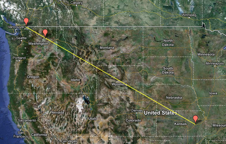
With the addition of Wilbur and the Pleiades summit to the alignments map, it seems there is no end to the correspondences that continue to arise by intuitively exploring the encoded information. The next installment of map additions and explications is coming soon, with additional power spots and several latitude/longitude synchronicities added. Next we’ll see what happens when we factor in the location of the Hopewell Mounds crop circle near Chillicothe, Ohio.
IMPORTANT NOTE: If you are new to Flat-Map Alignments, please see FMAs: FAQs.
STACE TUSSEL COLLIGAN
Click to explore Interactive Maps!
View Crop Circle Alignments (Original Map) in an Interactive Map
View Boulder-Teton-Wilbur Line in an Interactive Map
View Emporia to Pleiades Direct in an Interactive Map
View All-in-One Crop Circle Alignments Map in an Interactive Map (overview of the current established alignments I’m in the process of explicating)
The Sum of Its Parts: Finding Emergent Meaning in Crop Circle Maps
Monday, July 16th, 2012Crop circle communication is a process replete with symbols, riddles, and metaphor. Multiple possible meanings radiate from the shape and context of each circle, as well as through synchronicities of events, locations, and even unspoken thoughts.
By mapping seemingly-isolated formations and their associated synchronicities, the resultant geographies bring out meanings previously hidden in uncharted territory, affording us radical new insights into the language of the crop circles - and thereby the true nature of the phenomenon.
The map I’ll be explicating here is infused with evidence of what I call the Other Intelligence.
As Crop Circles Speak, the Map Speaks
We apply filters to just about everything we perceive. A cacophony of many voices falls away, for instance, when we hear our name spoken in a crowd; similarly, the meaning we derive from a crop circle is ours uniquely. But curiously, the alignments map instead met me with an agenda of its own - no external filter needed.
That a map like this would fall together in this way is unlikely, so acknowledging the alternative - that these elements have been shared with us this way, on purpose, by an intelligence we’ve yet to identify - is critical. With that acknowledgement comes the responsibility to listen. Listen.
The interpretation of the signal is, of course, a subjective task: I present it as I see it, and I encourage others to explore the territory by clicking on interactive map and reading the articles linked in the narrative. But again, at the most basic level, simply listen and the clues themselves will highlight messages encoded in the transmission.
The Origin of the Alignments Map
View Crop Circle Alignments (Original Map) in a larger map
The Topeka-Inman-Plevna line tipped me off about the Other Intelligence: the Inman formation appeared when wished for, and on a line that would eventually connect to the location where I later learned about it. In short, the place points on the TIP line are out of time-order, speaking to the relatively omniscient nature of the Other Intelligence.
Some measure of choice is necessary, both to provide a context and to help guide interpretation. I select Inman KS, Langdon ND, and Teton ID to anchor this map specifically because of each formation’s relative importance to me personally. The resulting triangle, along with the parallel TIP line, provides a visual hook - an element of design that resonates with the pleasing geometries of the crop circles themselves. Surely this map similarly contains messages awaiting discovery; I’m drawn in and begin exploring.
The triangle’s center highlights a vast and beautiful landscape, the Badlands of South Dakota, sacred to the indigenous people of the region. Specifically, the center is over Stronghold Table, or Onagazi - site of the the Lakota Ghost Dance in 1890 that eventually led to the Massacre at Wounded Knee.
As I look closer, a Native American theme continues to emerge. I learn that Teton is another word for Lakota - as in Lakota Sioux, who have especially strong ties to the Badlands.

I find Bear Butte on the line from the Inman circle through the center of the triangle (the Inman-Center line). Bear Butte rises almost a quarter of a mile above the surrounding plains. Here the Lakota and other tribes commune with Wakan Tanka, the Great Spirit, the central spiritual link connecting us with all of nature.
Black Elk said Wakan Tanka hears us even when we speak softly, which corresponds directly to crop circle phenomena, where private wishes and questions often elicit a response from the Other Intelligence. Bear Butte thus echoes an important theme of this map: “Communication with an Other Intelligence.”
The Teton-Center line eventually arrives at Spirit Lake, Iowa, site of an 1857 massacre in which white settlers were killed by a band of Santee Sioux in a backlash against the theft of their native land and broken treaties. In a double synchronicity, the Langdon-Center line also crosses the Spirit Lake Sioux reservation on the southern shores of Devils Lake. I’m hearing, “Beware of the modern materialistic life that severs our link with the natural world.”
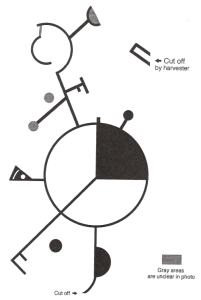
The Watertown SD crop circle of 1996, reached by extending a line from a point 1/4 of the way from Teton to Inman through the center of the triangle, virtually shouts intentional design embedded in the map. Specific elements built into the complex visual form of this crop circle refer to Kokopelli, a trickster figure associated with fertility and agriculture. The trickster is a shapeshifter who enchants and encourages us - just as crop circles themselves do. Here the message reads, “Pay attention, and have fun.”
As the import of the Lakota theme was reinforced time and time again, I experienced an epiphany relating to the cloud circle of 1998, which presented my friend Ron and me with an immediate, direct, and lucid response to a private conversation. Grandfather Sky is Wakan Tanka, is the Great Spirit, and is indeed responsive to our very thoughts and wishes, as Black Elk reminded us. I have yet to explore any clues that may arise from the cloud circle’s place point on the map, but that experience is now quite clearly a resonant thread in the map’s theme. I am reminded of the co-creative nature of crop circles. figure associated with fertility and agriculture. The trickster is a shapeshifter who enchants and encourages us - just as crop circles themselves do. Here the message reads, “Pay attention, and have fun.”
Other ties to the tribal theme are found in associated synchronicities that I’ve not detailed here yet, including one related to the discovery of the remains of a medicine wheel in central Kansas during a plane flight in search of crop circles. I’m also researching a Lakota connection to the star people of the Pleiades, and a possible tie with the numerous Pleiadean-themed synchronicities that accompanied my first crop circle experience.
More Alignments and Number Synchronicities
Aside from the Lakota theme, other clues and insights inform the map. Synchronicities and alignments are deftly interwoven here, each one turning up the volume of this conversation with the Other Intelligence:
· In a close correspondence, the total area of Kansas (82,282 square miles), my home state and the place I was introduced to crop circles at the Inman crop circle in 1995, comprise almost precisely 1/3 of the total area of the triangle (246,815 square miles). The 31 square mile discrepancy is negligible in the overall dimensions of the map. I take note of “one-third” as a potential message here.
· In another very close correspondence, on the Topeka-Inman-Plevna line, the Inman crop circle appears 39.86 miles from Plevna - almost exactly 1/4 of the 159 miles from Plevna to Topeka. Add “one-fourth” to the clues.
· Plevna, Montana, sharing a rare place name with Plevna, Kansas of the T-I-P line, appears in the vicinity of where the Inman-Center line connects with the Langdon-Teton line. This synchronicity, though of a smaller magnitude than the others described here, undoubtedly adds resonance to the map. Here I’m reading, “Home,” as Plevna is where I spent a good many years of my youth, and is still where I go home to when I visit Kansas.
· The Inman-Teton line passes fellow UFO and ET experiencer Mike Clelland’s residence at a distance of less than two miles - which is a doubly remarkable coincidence since Mike, like myself and many others, desired a crop circle encounter and directly received a formation in response. The message here once again echoes Black Elk’s reminder that the Great Spirit hears and responds even to our whispers.
· And if all of that were not enough, the Langdon-Center line eventually skirts the western edge of Boulder, Colorado - where I currently reside. I’m hearing two things here: “Culmination,” and “Be here now.” With this correspondence, I sense that the alignments map and all within it have come full circle, so to speak, and reflects the tribal wisdom that all things are created in a circle. While I’m grounded in Boulder, I’m being called to explore the Badlands, climb Bear Butte, and meet with the Lakota.
What Does All of This Mean?The facts of the map speak for themselves, and it’s up to us to interpret what is being said.
Since the map’s order and meaning arise directly from the overlay of meaningful correspondences tied to relevant points widely separated in time and space, I can only conclude that this map’s designer possesses a relative omniscience. The Other Intelligence wants to speak with us, and it’s no small talk - this is important stuff, and it’s ours to explore. Ultimately, the communication is what we make of it.
To me, the importance of honouring tribal wisdom is integral to the meaning of the alignments map. The Lakota and other indigenous peoples have honoured Earth and all creation through a way of life that’s deeply reverent of nature and spirit. The fragmentation of a people starts and ends with conformity to a way of life devoid of nature and short on respect, such as we see resulting from modern technologies that disconnect us from one another and from our life source. Wholeness can be regained by deliberately reconnecting with the natural and the spirit world through time-honoured ritual, respect, reverence, and gratitude - all of which are missing or minimised in the modern lifestyle.
The original Lakota way of life, now in jeopardy, is in alignment with the crop circle phenomenon, where meanings aren’t dictated by force or violence, but rather are communicated through patient guidance, a respect for individuality, and an emphasis on the natural world. Crop circles aren’t imposing anything; they aren’t out to hurt anyone or pollute the environment.
With gratitude to the Other Intelligence, I carry on this conversation.
IMPORTANT NOTE: If you are new to Flat-Map Alignments, please see FMAs: FAQs.
STACE TUSSEL COLLIGAN
No comments:
Post a Comment